


le canet

clintest
User

Length
16.1 km

Max alt
440 m

Uphill gradient
440 m
Km-Effort
22 km

Min alt
129 m

Downhill gradient
438 m
Boucle
Yes
Creation date :
2021-09-29 07:04:07.171
Updated on :
2021-09-29 13:18:38.958
6h14
Difficulty : Very difficult

FREE GPS app for hiking
 SityTrail
IGN / Geographical institutes
SityTrail Plus
The world is yours!
About
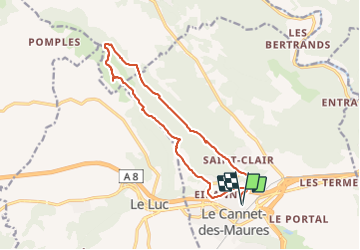
Trail Walking of 16.1 km to be discovered at Provence-Alpes-Côte d'Azur, Var, Le Cannet-des-Maures. This trail is proposed by clintest.
Positioning
Country:
France
Region :
Provence-Alpes-Côte d'Azur
Department/Province :
Var
Municipality :
Le Cannet-des-Maures
Location:
Unknown
Start:(Dec)
Start:(UTM)
284953 ; 4808014 (32T) N.
Comments